Your Privacy Choices
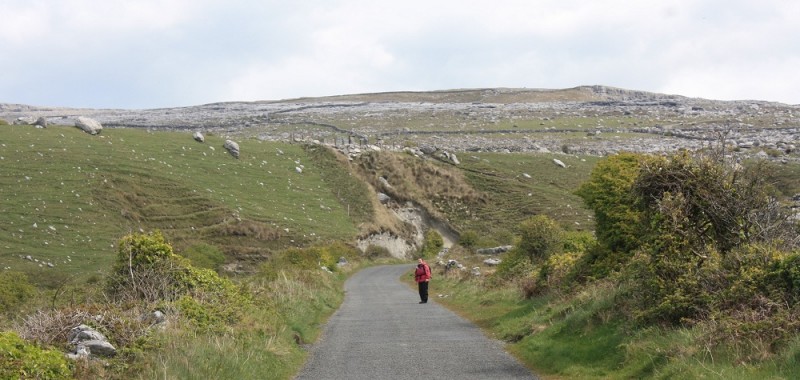
Jan Duprey walks a green road during the Caher Valley Loop in Ireland's County Clare.
Though the Emerald Isle conjures up images of lush, green landscapes, there exists on the Atlantic enclave a stark, otherworldly place known as the Burren.
Rivers typically flow underground. The layered and checkered-looking mountains are made of limestone. Hardy plants cling to life. Fields of stone dot the landscape. The valleys are craggy.
The Burren is aptly named, taken from the Gaelic, meaning “rocky land.” Located in northwest County Clare, it is wonderfully off the beaten path for those who rarely stick with the masses going to the Ring of Kerry to seeking to kiss the Blarney Stone.
The area is one of the largest karst landscapes in Europe, defined by Wikipedia as “a geological formation shaped by the dissolution of a layer or layers of soluble bedrock usually carbonate rock such as a limestone or dolomite.” Basically, it makes it look like the moon in places.
So instead of getting on a waiting list for a lunar launch—and frankly, I don’t have anywhere enough frequent flyer points—my lady who likes to leg it, Jan Duprey, and I decided to point the rental car for the windswept plateaus. There is a national park to see, which we did, but we felt the best way to experience was not getting into and out of the car, but instead on an extended hike.
With ample color-coded trails, maps and hand-outs in the area, we came upon the Caher Valley Loop Walk, a roughly nine-mile circuit from the sandy beach in the village of Fanore, between Ballyvaughan and Doolin. With a projected time of three to four hours, we made sure to first stop to pick up local bread, cheese, and deli items before venturing along a small stretch of the road and “green roads”–pathways that are more a dirt road or country lane than a narrow winding trails.

St. Patrick’s Church in Fanore Ireland sits against the backdrop of the Burren.
The route started benignly enough under the gray skies, typical for Ireland, as we went by the St. Patrick’s Church, which was built in 1870 on the green road. The church was set against the stark karst plateaus, setting the scene for the wild walk that followed the snaking Caher River, known as the only river in the Burren to run along the surface.
The hike on the western edge of the Caher Valley went through a gorge-like area locally called the Khyber Pass, perhaps named by soldier with the British Army stationed overseas.
Horses grazed on grazes, with ancient stone walls acting as borders. Tiny homes dotted the road, many with playful gardens. There were other hikers too, from Ireland–but not many locals. Spring seemed to be a good time for many to get away, with lower lodging rates than prime time in summer.
The loop led to the Burren Way, a 71-mile long-distance hiking trail over roads, tracks, and paths that many generally do in about five days. Perhaps that is for another time, but on this day, the pathway led up by the ruins of a chapel used until St. Patrick’s was built. Up the way there were incredible stone walls, all neatly stacked and standing. From the top, like a ride, we stopped amidst the stones for a well-earned lunch and admired the sweeping landscape of Galway Bay, the Aran Islands, and the hills of Connemara.
As we started the descent, all too soon on such a delight of a hike, we kept eyes out for what remained of Faunarooksa Castle. We stumbled upon old stone rundown cottages and the the round house style castle.
All too soon we left the barren landscape and found ourselves among tidy homes, including one with palm trees–making us realize how temperate the valley must be compared to other sections of Ireland.
And when we reached the carpark with the sea on one side and the mountains on the other, we understood the draw of the Burren.
Images by Marty Basch