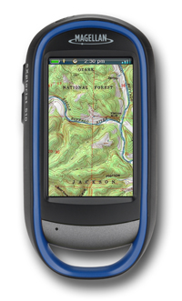
Magellan, a leader of innovative GPS devices for vehicles, fitness, outdoor and mobile navigation, today announced the new Magellan eXplorist 310 and eXplorist 510 TOPO! Editions to give hikers a best-in-class total navigation solution featuring National Geographic’s TOPO!, the most detailed outdoor recreation topographic maps of the U.S., combined with Magellan eXplorist 310 and 510 Outdoor GPS receivers. Magellan will display its full line of new eXplorist GPS Editions — the Magellan eXplorist Angler, eXplorist Pro Angler, eXplorist Marine and eXplorist TOPO! Editions — at the Outdoor Retailer Summer Market show (Booth #22009) this week in Salt Lake City.
The Magellan eXplorist TOPO! Editions include Magellan’s rugged, waterproof, handheld eXplorist GPS receivers with sunlight-readable screens and National Geographic’s TOPO! navigation content. In addition to the topographic content, the Magellan eXplorist 310 TOPO! Edition includes a lightweight Magellan eXplorist 310 outdoor handheld GPS with a 2.2-inch color screen, rich graphics and a simple user interface. The Magellan eXplorist 510 TOPO! Edition features a built-in camera, microphone and a large 3-inch color touchscreen that allows hikers to see more areas of a map which will assist them in planning their routes. Consumers can download the TOPO! content at http://www.magellangps.com/outdoor and enter a special code included in the box. One year of unlimited content downloads are included with each Magellan eXplorist TOPO! Edition and consumers can keep all of the maps they downloaded after the 12-month subscription.
“Magellan is focused on developing a series of top-of-the-line eXplorist special editions that deliver a total navigation solution for hikers, anglers, boaters and hunters,” said Warren Hewerdine, Sr. Director of Marketing for Magellan. “The new eXplorist TOPO! Editions give hikers the topographic maps they want plus the dependable GPS hardware they need to maximize their outdoor experience.”
National Geographic’s TOPO! includes authentic, full-color USGS topographic maps, scanned at high resolution and seamlessly tiled together. This unique process creates the highest detail and best image quality possible, essential for top-quality navigation and outdoor safety. Adding TOPO! to Magellan’s eXplorist GPS devices provides map detail levels including USGS 1:100,000-scale topographic, ideal for planning and visualizing long trips, and USGS 1:24,000-scale topographic for fine detailed terrain maps. These solutions are ideal for detailed wilderness navigation ranging by locating ridge lines and ravines as well as for finding national and state parks and other destinations in the U.S. Users can also view a unique collection of road and trail data that shows a complete network of back roads and trails on a national scale.
Available in August from MagellanGPS.com and Magellan’s authorized retail and online partners, the Magellan eXplorist 510 TOPO! Edition is $299.99 (MSRP), and the Magellan eXplorist 310 TOPO! Edition is $199.99 (MSRP).
Image courtesy of Magellan

 Your Privacy Choices
 The
The