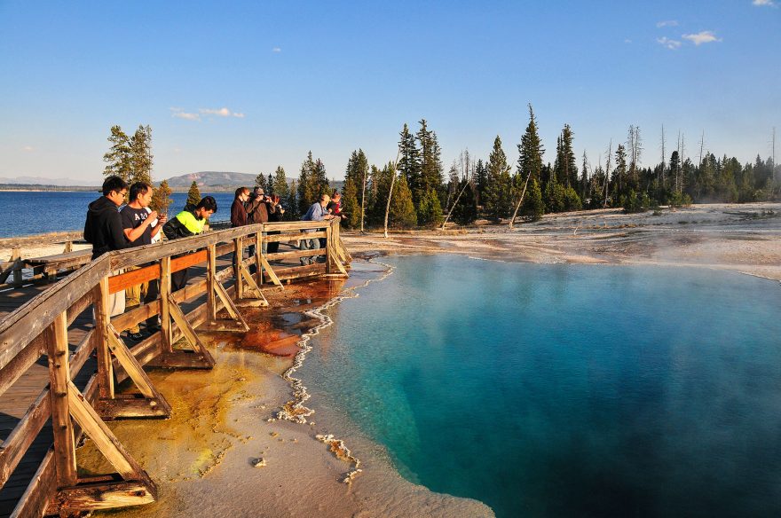
Image by Matthew Thomas Allen, Shutterstock
Yellowstone National Park is a place of wonder. With hydrothermal and geological features — some unlike anywhere else on earth — visitors have been drawn to Yellowstone for nearly 150 years since it became designated as the first U.S. National Park in 1872. In 2020 alone, park rangers counted more than 3.8 million park visitors.
And although famous for its geysers, Yellowstone is equally famous for its wildlife — providing habitat for more than 65 species of mammals, 16 species of fish, five species of amphibians, six species of reptiles and nearly 300 species of birds. That’s what makes day hiking in the park so unique … and entertaining.
Not only will you witness the breathtaking landscapes of mountains, bodies of water and geothermal features, your chances of viewing wildlife while hiking in Yellowstone is high. Day hikers walking on trails in Yellowstone commonly see wild animals like American bison, bears, elk, bighorn sheep, coyotes and wolves. You can even see more elusive animals in certain seasons like moose, red fox, mountain lions and perhaps a rare look at a wolverine.

Image by Ben Wickham, Shutterstock
But planning a trip to Yellowstone National Park can seem overwhelming with more than 3,400 square miles of terrain to choose from. And choosing a day hike can be a big task with a solid 34 options.
In total, Yellowstone has about 1,000 miles of backcountry trails for visitors to explore — which is like walking across the state of Montana from east to west nearly two times. So it’s best to know exactly where you’ll be hiking, have a map and plan ahead.
In Roger Anderson and Carol Shively’s book, A Ranger’s Guide to Yellowstone Day Hikes, you’ll get the most solid and up to date trail information in Yellowstone. Anderson and Shively field tested each hiking trail for accuracy and hiked every mile of every trail in their book. And they are both retired park rangers, making them resident experts in all things hiking in Yellowstone National Park.
Here are three easy (and beautiful) day hikes you can feel confident doing when you visit Yellowstone National Park:
View this post on Instagram
Trout Lake
This short 1.2 mile hike to Trout Lake is a gem that’s not widely known to park visitors. And finding the trailhead is a treasure hunt in itself and easiest with a park map. The scenic drive is full of beauty and photo-worthy.
Along the trail you’ll see mountains from afar, and a variety of evergreen trees like Douglas firs. And since you’re in the Absaroka mountain range with tall jagged peaks, you’ll notice the terrain looks a bit different than a lot of other areas in Yellowstone National Park. In the spring, you’ll even see waterfalls on Mount Hornaday in the distance.
You’ll also cross a small wooden footbridge along the hike. And if you happen to be there at the right time when you reach the lake (typically June into July when the water temperature in the lake reaches 41 degrees) you’ll witness the cutthroat trout spawn. Anderson and Shively write, “Twisting and slapping their tails, the females dig small holes, called redds, in which they deposit their eggs. Known for the red gash-like stripe on their throat that gives them their name, the cutthroat trout also display a bright red patch behind their gills during the mating season.”
If you’re looking for a nice and easy two-hour day hike in Yellowstone with a gain/loss of only 200 feet, this one is for you. This hiking trail is also not as populated as some of the other popular hikes in the park, so you’re sure to enjoy the sounds of nature at every turn.
Anderson and Shively give these directions:
Trailhead: This hike starts from the pullout on the north side of the Northeast Entrance Road, 1.2 miles west of Pebble Creek Campground, and 17.7 miles east of Tower Junction. GPS: 55.899148, -110.123048
Hiking directions: From the trailhead, climb 200 feet in 0.3 miles to the shorts of Trout Lake. Follow the trail as it loops around the lake. Return to the trailhead by the same route.
View this post on Instagram
Natural Bridge
You’re in for a treat with this easy day hike in Yellowstone National Park. And the name of the hike gives away what you’ll see — a natural rock formed bridge (or arch). You’ll want to plan ahead though as the trail doesn’t open until mid- to late June and is closed during the spring when grizzly bears frequently roam the area.
This 2.5 miles round-trip hike is filled with meadows, and you’ll hike through forested areas to reach the Natural Bridge. You’ll also cross three wooden footbridges, encounter large boulders, walk through shaded areas and see old tall trees and a variety of wildflowers.
Once you reach the Natural Bridge, you’ll witness this geological formation that stands 50 feet tall and spans nearly 30 feet across a creek. There’s even a small switchback trail you can take to the top where you can enjoy the picturesque view of Yellowstone Lake down below.
Anderson and Shively give these directions:
Trailhead: The hike starts in the Bridge Bay Area, 3.4 miles south of Fishing Bridge Junction and 1.8 miles south of Lake Area Junction. If coming from the south, it’s 17.2 miles north of West Thumb Junction. GPS: 44.534048, -110.438188. As you enter the Bridge Bay Area, the trailhead is located on the right, just past the campground entrance. Parking is on the left at the marina.
Hiking directions: From the marina parking area, cross the road to the trailhead and follow the paved path to the campground. Reaching the campsites, the trail takes a sharp left turn. Hike 0.7 miles to where it meets the old road, now a hiking/biking path. Bear right. Continue 0.4 miles, the stay on the right where the road ends in a turnaround loop at the Natural Bridge. From the wayside exhibit, climb 50 feet to the top of the bridge. (Do not cross the Natural Bridge itself.) Cross the creek behind the bridge and loop back to the road. Return to the trailhead by the same route.
View this post on Instagram
Mystic Falls
If you’re drawn to waterfalls, this easy day hike is one you should check out. The reward on this hike is witnessing a 70-foot cascading waterfall that descends over the edge of an ancient lava flow.
At just 2.2 miles round trip, this day hike is easy to do in 1 to 2 hours and is usually open to hikers the last week of May each year. Although be aware that due to bear activity, you should always check with the Ranger Station before you go out hiking to be sure that the trailhead is open.
On this hike, you’ll cross a footbridge and wind your way through a few geyser basins. And your journey will take you through Biscuit Basin, which is part of the Upper Geyser Basin and home to geysers like the famous Old Faithful.
“You’ll pass several sparkling blue pools — Black Opal, Wall Pool and Black Diamond — before reaching the brilliant and mesmerizing Sapphire Pool, the most prominent feature in the small thermal area,” write Anderson and Shively in their book.
You’ll continue on, passing a river with small rapids and a small hot spring seeps scattered along the river’s edge with wildflowers. You’ll hear and see the falls once you reach the river. And you can enjoy the view of the waterfall from the base or go on a short climb to another viewpoint higher up.
Anderson and Shively give these directions:
Trailhead: This hike starts from the Biscuit Basin parking area, 2 miles north of the Old Faithful overpass and 14 miles south of Madison Junction on the Old Faithful Madison Road. GPS: 44.485060, -110.852432.
Hiking directions: From the Biscuit Basin parking area, cross the footbridge over the Firehole River and continue straight on the boardwalk, passing Sapphire Pool, to the far end of the basin. Past Avoca Spring, turn left at the junction and follow the boardwalk to where it ends and the trail to the falls begins. Continue straight on the trail toward the falls. In 0.3 miles, the trail reaches the junction with the loop trail descending from the geyser basin overlook. Keep left on the lower trail. Hike another 0.5 miles to Mystic Falls. On the way, pass the Summit Lake Trail on the left before arriving at the base of the falls. A bit farther up the trail, there’s a nice view from the top of the falls. If Mystic Falls is your destination, retrace your steps back to Biscuit Basin.
Suzanne Downing is an outdoor writer and photographer in Montana with an environmental science journalism background. Her work can be found in Outdoors Unlimited, Bugle Magazine, Missoulian, Byline Magazine, Communique, MTPR online, UM Native News, National Wildlife Federation campaigns and more.
 Your Privacy Choices
 (@geoffpiperphotography)